Week ahead forecast for Cavendish Open Week

Issued at 0830 Tuesday, 4 August 2020

General situation:

Warmer and more humid air will extend northwards later this week as previous fronts clear away. Although pressure will build for a few days, there is a chance of local thundery showers forming over the weekend, but very hit and miss. During next week, high pressure is likely to gradually give way to a thundery low becoming located to the southwest of Britain, although the timing is uncertain.


Tuesday: Cloudy, becoming mainly dry    

Patchy rain this morning will fade out to leave the rest of the day dry, although mainly cloudy. Winds strengthening, to southwesterly 20-25mph later in the day, possible stronger gusts this evening.  Max 17C, dropping only marginally to 14 or 15C for a humid night.

Wednesday: Risk of rain early and late, much of day dry    

Pulses of rain are likely to encroach in from the northwest as a front pushes southwards tonight, this may be around first thing on Wednesday morning for a few hours, giving a couple of mm most likely, before the front then wriggles back north and breaks up for a time. Low cloud across the hills, but much of the middle of the day should be dry with some brightness. A risk of pulses of rain returning from the southwest later afternoon or evening, with the odd heavy burst possible as the front finally pushes through, with another 2-3mm if this develops. Winds southwest 15-20mph. Max 19C, humid.

Thursday: Warm, cloud breaking    

Early low cloud and pockets of drizzle will fade in the morning to leave skies brightening with some sun coming through and the rest of the day generally dry. Warm and humid with light southerly winds, max 23C, staying up around 16C into the night.

Friday: Hottest day of week    

Most likely dry throughout. Any early mist soon gone to leave mostly sunny skies. Light southerly winds, rising to 26C by afternoon. Chance of a late thundery burst of rain coming up from the southwest by evening into the night, but very hit and miss.

Weekend: Generally dry, sunny    

Generally dry, but less hot. A good amount of sunshine and light winds. Temperatures 20 to 22C by day, and 11 to 13C overnight. Small risk of a thundery pulse of rain drifting up from south late Sunday.

Next week: Rain likely to develop    

Likely to start generally dry, as high pressure stays around across Britain. However, as low pressure drifts gradually up from the south, it is likely to give way to bursts of rain. The timing of this change is very uncertain at present, but the general view of becoming frequently wet for a spell into mid-August is the more likely pattern at this stage – so favouring a deterioration as the week progresses.
Cavendish Open Week Prep

Issued at 0900 Monday, 27 July 2020

General situation:

Low pressure sweeps northeastwards to begin the week, then pressure builds for a time in midweek. Further fronts push north on Thursday, but this ushers in briefly very warm and humid conditions. 

By the weekend, cooler and showery weather may well return, interspersed with drier periods. Typically mixed conditions into the first week of August. 


Outlook for this week:

Monday: Heavy rain    

Pulses of heavy rain throughout the day – easing occasionally, but torrential bursts at times with possible thunder, only fully clearing into the evening and night. Brisk winds, south later westerly, 15-20mph. Max 16C, dipping to 9 or 10C tonight.

Tuesday: Windy, risk showers    

Breezy through the day, west to northwest 15-20mph, sometimes 25mph. A few showers, mostly passing through on the wind, but may give 2-4mm if these cluster for a time. Occasional sun. Feeling cool, Max 15C; Min 10C.

Wednesday: Generally dry    

Dry most or all day with variable cloud and occasional sun. Chance of a light shower giving less then 1mm early morning. By evening, cloud building from the southwest, with a risk of some rain developing into the night. Winds west to southwesterly 10-15mph, easing slightly. Max 17C; Min 12C.

Thursday: Warmer    

Cloudy skies, with chance patchy drizzly rain at first, but amounts small, and likely clearing to leave some sun breaking through. Wind southerly around 10mph. Quite humid, warmer. Max 21C; Min 15C into the night.

Friday: Hot sun    

Most likely dry, with more sunshine and the hottest day for the past month, max 26C. 

Chance a thunderstorm into late evening or night.

Weekend: Showery bursts, risk thunder    

Some uncertainty of detail and timing, but a risk of bursts of rain spreading from the southwest as cooler air soon returns. There may be thunderstorms, but these hit and miss. Southwesterly winds likely to strengthen. Max 18 to 22C; Min 11 to 14C.

Next week: Changeable    

At present the best description is ‘not settled’. Low pressure is likely to be nearby, bringing spells of rain or showers in from the southwest, sometimes heavy or thundery. Rarely hot, mostly 17 to 20C.

Hit and miss downpours

A warm, humid and unstable atmosphere will exist over the British Isles in the coming days – the recipe at this time of year for some heavy bursts of rain and thunderstorms.

A slow-moving area of low pressure will drift around through the weekend into the early days of next week, with areas of rain and low cloud encircling the low. There’s some dry weather too, and a little sunshine, but generally hazy.

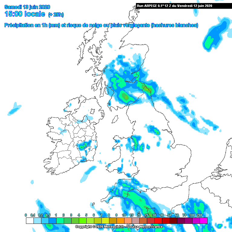
Rain and drizzle over northern England on Saturday morning will tend to drift away north and westwards, with drier conditions following. Extensive hill fog to low levels, particularly in eastern Pennine areas early morning will gradually lift, and some sun will break through. One or two areas of showers will then form through the day, but not everywhere will see them, so it really does just come down to luck of the draw.

The model chart shown below is the best indication we have for where showers will form on Saturday afternoon.

Showers are likely to become more widespread and potent from Sunday onward through Monday and Tuesday, forming generally into the afternoons, when some slow-moving torrential downpours with hail and thunder are to be expected down the spine of the Pennines. Again, hit and miss, but the risk is greater and more widespread of catching the downpours. 20-30mm+ in an hour in some locations will cause local flash-flooding in these situations.

Things are due to become quieter from midweek onward, as pressure slowly builds from the west, and a couple of drier days are likely by Thursday-Friday.

There’s then a question mark about how soon pressure falls again from the west, and whether further unsettled conditions move back in for a time.

Temperatures will be better than recent values at least, with maxima commonly into the low 20s, with overnight values no lower than 10C. Damp air will hang around, so early murk is always a possibility in the hours after dawn.

At least our golf courses are greening up nicely now, and the putting surfaces have welcomed the drink. Let’s hope our weather machine knows when to turn the taps off…

1


What a difference a week makes!

A week may be a long time in politics, but it’s also certainly a long time when it comes to our glorious British weather!

We have moved from high pressure and endless days of sunshine through much of May, to the prospect of the first weekend of June being plagued by heavy downpours.

Useful rain at least, as many courses were certainly in need of a drop, so maybe we shouldn’t complain, but we could do without reaching for the brollies and wetsuits for Saturday’s golf!

Here’s the latest weather plan for the next few days:

Low pressure is pivoting around over the North Sea into the weekend. Cold air at upper levels in the atmosphere means things are quite unstable. This produces frothing cumulus clouds, and ultimately some heavy and thundery downpours.

This upper ‘trough’ will be over central-northern England through Friday and Saturday, with scope for showers to locally band together due to local converging winds.

This means there is still a degree of ‘hit and miss’ about who gets what in terms of downpours. A few miles either way can make a big difference! A realistic 5mm in half an hour is to be expected, with 10-15mm in the day if you get hit a few times.

Friday is likely to see showers pretty widely, so you’ll do well to miss everything. There’s a tendency for clusters of showers to concentrate into areas east of the Pennines in the afternoons in these cyclonic northwesterly episodes, but there will always be a few bands of showers which form around Lancashire and try to move into the western Peak District and Staffordshire. Watch out for thunder and lightning because things are lively enough for that in the current setup.

By Friday night into Saturday, northwesterly winds will strengthen, with gusts toward gale force, 35-40mph, which will bring some debris down from the trees. A more organised zone of rain is expected to pivot southwards across northern England into the Midlands from pre-dawn into Saturday morning, lasting several hours. This combined with continued strong winds and chilly temperatures only 6 to 8C means it’s not looking so clever for your morning socially distanced three or fourball…

As this system pivots in on early Saturday, a 6-8 hours rainfall accumulation of 15-25mm in the western Peak & Pennines is looking believable, as strong west-northwest winds drive into this part of the world, and throw their moisture at the hills.

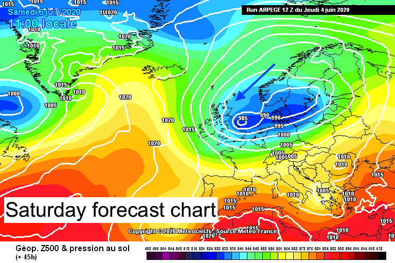
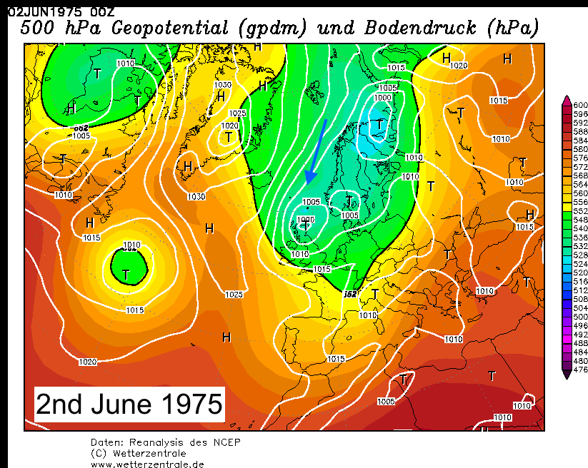
I say this with appropriate caution, but it’s a weather situation which is not far removed from the one which brought the infamous ‘snow stops play’ to Buxton in June 1975 (see charts below). Delving into the archives, I reckon that airmass was inherently more purely ‘Arctic’, whereas this one is merely Scandinavian in origin. It has come from the same sort of weather setup though, with a cyclonic northerly regime in charge for a few days. It would only take a few more degrees worth of temperature fall within a heavy rain band early Saturday to find something sleety in the mix. I think you’d have to go up Cat and Fiddle or onto Kinder plateau to find this, but it’s not a million miles away.

Rrea00119750602

arpegeeur-0-45

By Saturday afternoon, things should be breaking up into showers, but the odd lively one is still likely. The worst of the winds are expected to ease too, and temperatures should recover toward 13 to 15C in any sunshine.

By Sunday, pressure begins to build, and whilst it stays cool with a risk of showers, they will likely be more scattered, with variable cloud and sunshine. Highs of only 13 to 15C are still not exactly summer-like!

Early next week is expected to see high pressure nudge further across Britain, with less strength than recently, but should be enough to give some dry days again. An odd shower or weak frontal band giving patchy rain will remain possible.

In the longer range, most trends favour high pressure lying to the north/northwest of Britain, whilst low pressure wants to be focused to the south over Europe, so east or southeasterly patterns may be the most common. Temperatures trending upward with time. Some showery activity is likely, but depends just how the various weather patterns shuffle around.

We could do with some rain to keep things lush, but not too much to spoil our summer!

Sunshine all the way this weekend

Things are very much set fair into the weekend, as high pressure dominates across the British Isles.

It’s a pretty simple forecast in the short term, with lots of sunshine and blue sky. A chance of local mist pockets just around dawn, but those will soon burn off.

Temperatures rising into the low 20s Celsius into the afternoons, and some spots in northwest England to the lee of the Pennines may nudge 23 or 24C.

A general light east to southeasterly breeze will prevail, so eastern parts of the Midlands will tend to be a little cooler, with the air moving inland off a cool North Sea.

Overnight temperatures will dip into single figures out of towns, and some spots over the weekend may find themselves around 5C in Pennine areas just at dawn, so a dewy start is to be expected at first light.

Into next week, it gets a little more complex, as pressure falls a little, with the scope for isolated pop-up showers forming on some days. Most indications make these very hit and miss, with a mostly dry theme still looking likely into the first week or so of June with high pressure still nearby.

One or two forecast model simulations do make showers pop up more widely with time, but trust this at your peril if you’re itching for rain… It may come to nought for most places!

The temperature will ease back a bit next week as the air mostly approaches the UK from the north or northwest. Expect a bit more cloud, and maxima in the 16 to 21C range, whilst overnight will typically fall between 5 and 10C.  Chillier nights are possible later in the week, so keep an eye on that one.

The likelihood into the second week of June is that high pressure is stationed to the west of the country with northwesterly weather patterns prevailing. Some suggestions lean toward the Atlantic patterns trying to make a stronger comeback for a time. I would suggest for now that things are likely to stay more often dry, but looking rather on the cool side on some days.

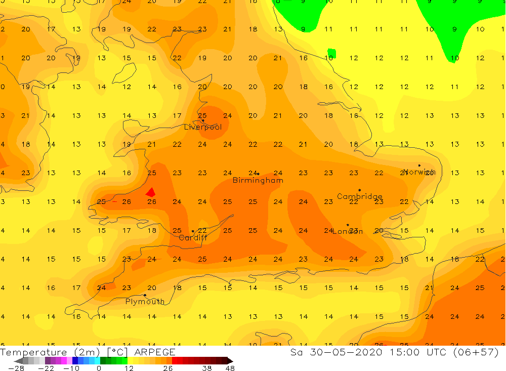
This Saturday afternoon’s maximum temperatures are shown below.1